Hiking & Camping

The Town of Warwick was named an A.T. Community in 2012
Useful Links
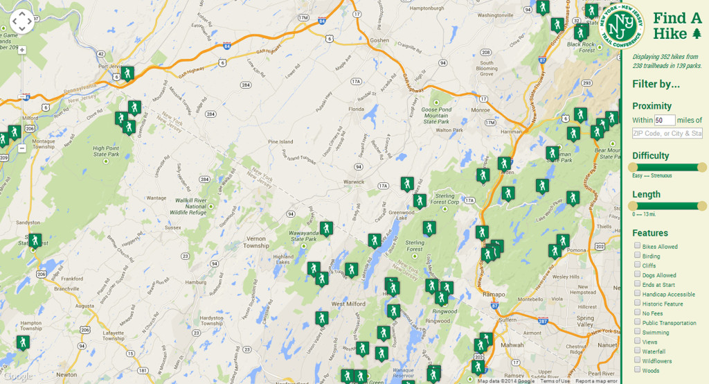
PLAN A HIKE
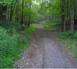
Appalachian Trail North of Route 17A in Warwick, NY (click for details)
 Overview: This out-and-back hike climbs to two fascinating puddingstone rock outcrops, with panoramic views.
Time: 3 hours
Difficulty: Moderate
Appalachian Trail on Bellvale Mountain (click for details)
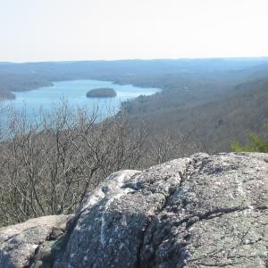
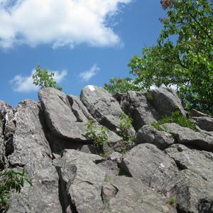
Overview: This hike traverses the ridge of Bellvale Mountain, climbing over unusual puddingstone conglomerate rock outcrops and reaching many beautiful viewpoints over Greenwood Lake.
Time: 6 hours
Difficulty: Strenuous
Length: 7.1 miles
Route Type: Shuttle/Two car or Public Transportation
Dogs:Allowed on leash
Sterling Ridge Trail/Fire Tower Loop from Route 17A (click for details)
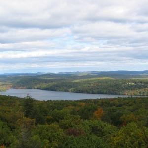 Overview: This loop hike traverses Sterling Ridge, includes a fire tower, offers great views and a walk along scenic Sterling Lake.
Title: Wood Duck Trail
 Location: Rte. 565 .1 mile within the Wallkill River National Wildlife Refuge.
Description: This circuit 4 mile hike on a former railroad bed is an ideal family trek that is flat but elevated over a series of natural habitats. Open marsh, bottomland swamp forest, hardwood forest and shrubby fields greet the hiker with great opportunities to enjoy seeing wildlife such as muskrat, beaver, and even black bear. The Wood Duck Trail is great for birdwatchers in search of rarities such as Barred Owl, Great Blue Heron and Wood Duck. It is a great place for kids to see turtles and frogs too!
Difficulty: Easy
Title: Appalachian Trail (Canal Road section)
Location: Canal Road, Wawayanda State Park, Vernon Township
Description: The Canal Road section of the Appalachian Trail is a four mile gentle stroll that ends at Rte. 94. The AT here represents the most panoramic viewsed of entire trail system while wending through corn fields, forest groves, wetlands and shrubby pasturelands against the of the Wawayanda and Pochuck Mountain ranges. The trail is great for nature observation, botanizing, bird watching and for a short hike. Canal Road is part of Vernon Township’s Biking Trail for family oriented road bikes tours.
Difficulty: Easy
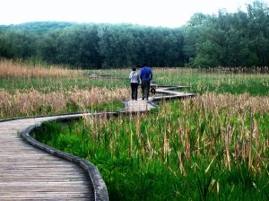
Title: Appalachian Trail (Pochuck Creek section)
 Location: Rte. 517, Vernon Township
Description: This handicap friendly 4 mile hike takes you along an elevated wooden trail over the Pochuck Creek marsh and crossing the Pochuck Creek along a suspension bridge. Afterwards, the AT enters the largest protected limestone forest in Vernon Township with several centuries old trees and rare and unusual wildflowers. This section of the AT is hugely popular and frequented by thousands of visitors every year. Many activities take place here including, nature observation, bird watching, trail running, and short and through hikes.
Difficulty: Easy
 Title: Appalachian Trail to Pochuck Mountain
Description: This 4-mile, ‘forgotten portion’ of the Appalachian Trail to the summit of Pochuck Mountain is a steadier, easier climb than Wawayanda Mountain but completely in the woods. The mountaintop is mostly flat with mixed hemlock and hardwoods. An interesting vernal pond always seems to have turtles and frogs. You may even find a mink hunting amphibians, or the resident pair of Barred Owl.
Difficulty: Intermediate
Title: Highlands Trail to Buckabear Pond
Description: This 4-mile switchback trail parallels Clinton Reservoir. The tour provides great views of the reservoir and Bearfort Mountain. The uneven terrain traverses under a climax forest with a rich understory of shrubs and wildflowers in spring and summer. You will pass a beaver dam and giant tulip trees amongst splendid solitude at Buckabear Pond – an ideal stop for a quiet lunch. The trail provides great snowshoeing in winter, too. Maps are available thru the NY/NJ Trail Conference or at Crystal Springs Resort shops.
Difficulty: Intermediate
Title: Lounsberry Hollow Trail
Description: Little known and seldom used, this nature sanctuary owned by the New Jersey Audubon Society is a 250 acre portion of Pochuck Mountain is a destination for hikers and nature lovers wwho enjoy solitude and exploration. The preserve has well blazed trail undulates through a number of summits and ravines with rarely seen panoramic views of Vernon Valley from the west looking east. The trailhead is a located on the south side of Lounsberry Hollow Road in Vernon.
Difficulty: Intermediate
Title: Appalachian Trail Barrett Rd to Pinwheel Vista
 Location: Barrett Rd, Vernon Township
Description: This hike starts at Barrett Rd and goes to the Pinwheel Vista. It is a section of the Appalachian Trail. It is a nice alternative to get to the vista without having to climb the strenuous face of the front part of the mountain. This trail is approximately 2.4 miles with rolling hills. Follow the white blazes. You will cross a stream and head south to the vista. When you see the blue blazed trail on the right, take that right and the vista will be a few yards in front of you.
Difficulty: Intermediate
Title: Dagmar Dale (North Loop)
Location: Wallkill River NWR Headquarters, Rte. 517. Vernon Township
Description: This 3 mile circuit trail is a gradual descent to the Wallkill River riparian corridor compete with a sturdy bridge over the waterway. Starting with panoramic views of the Wallkill Valley, the Dagmar Dale trail introduces the nature enthusiast to a bevy of wildlife habitats; beaver marsh, grassy meadows, overgrown shrubby fields and mature forests. The return hike requires the hiker to ascend several hundred feet to return to th e parking lot. The refuge headquarters has plenty of parking, bathrooms and a water fountain
Difficulty: Intermediate
Title: Hamburg Turnpike Trail
Location: Hamburg Mountain WMA, Hardyston Township
Description: This little known trail begs to be discovered! Located off of Mountain Avenue, the Hamburg Turnpike Trail is a former colonial road that begins as a short residential street culminating at a significant woods road that climbs steadily until you reach an elevation of 1400 feet. Crossing mountain streams, remnant hemlock forest and dry ridgetop woods, the trail crosses a series of beaver marshes and across the Silver Grove Lake Wildlife Management Area before entering the vast Pequannock Watershed. NJ Endangered Red Shouldered Hawk, Barred Owl and Goshawk nest near the trail.
Difficulty: Intermediate
Title: Livingston South Trail
Description:This seldom used trail is well blazed and easily accessed from Breakneck Mountain Road. Starting from a small pond, the trail hugs the ridgetop overlooking Vernon Valley with scattered overlooks and interesting rock formations heading north to a junction with the Appalachian Trail several miles away. The trail is mostly level with no challenging climbs or rocky areas. Several offshoot trails meet with the main Livingston Trail. Consult the Wawayanda State Park map for more information. The map can be obtained by visiting the park headquarters or for more information please visit The NJ State Parks Web Site
Difficulty: Intermediate
Title: Pumphouse Trail
Location: Wawayanda State Park, Vernon Twp.
Description: The Pumphouse Trail is one of many beautiful trails found in Wawayanda State Park. The trail itself is rugged with many short ascents and descents while crossing hemlock forests, ten foot tall rhododendrons and hardwood swamps. Seeing Black Bear or one of many interior nesting songbirds is to be expected in spring and summer. Several offshoot trails crisscross the main stem with one path offering great views of Wawayanda Lake from the south. The trail ends at a remote corner of the park by Cherry Ridge Trail.
Difficulty: Intermediate
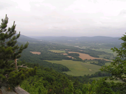
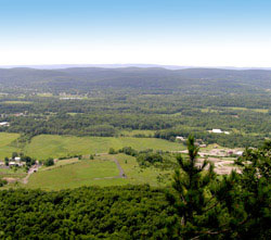 Title: Appalachian Trail to Pinwheel Vista
Location: Rte. 94, Vernon Township
Description: The most heralded hike in the region! If you climb the 700 foot climb in less than a mile, you will enjoy the one of the most breathtaking viewsheds in the Highlands region. The hear pumping adrenaline rushing ascent is not for the faint of heart nor if you are not in good physical condition, nevertheless, the reward of seeing Slide Mountain, the highest point in the Catskills, High Point State Park, the highest point in New Jersey and the sweeping pasturelands of Vernon Valley on a clear day will last a lifetime. The trail is underrated for the abundance and great variety of butterflies, birds and wildflower blooms that are a must see for the nature enthusiast.
Difficulty: Strenuous
Title: Hamburg Turnpike to Silver Grover Wildlife Management Area
Description: Climbing Hamburg Mountain along an old colonial road is fun but steep until it levels for an easy jaunt to Silver Lake, an old boys scout camp, now a wildlife management area. The experienced hiker will cross many streams, see talus slopes and enjoy a vast network of beaver ponds, and scattered hemlocks, this area of the Hamburg Mountain Wildlife Management Area. Seeing beaer, bear, fox and over 70 species of nesting birds is possible here.
Difficulty: Strenuous
Title: Appalachian Trail to High Point
Description: Climbing High Point to a summit of 1801 feet the highest point of New Jersey is a strenuous but exhilarating experience whose reward is to see the monument and the 360 degree panoramic views of three States; Pennsylvania, New York and New Jersey. The 3 mile climb is rugged, rocky and steep. Experienced hikers need to bring sufficient water and snacks. Sturdy shoes or boots, hiking pole and mosquito repellent are strongly recommended for the summer months.
Difficulty: Strenuous
Use the “Find A Hike” App from the NYNJTC to find trails in the area!